Showing posts with label maps. Show all posts

Monday, December 5, 2022

Anyone looking for a 2023 #Ward06 elections page?

Remapped 6th Ward - adopted May 2022

The map you see above is of a remapped 6th Ward which was adopted in May 2022. This is the ward that candidates for Alderman will be running to represent.

At this moment I don't know if there will be an election page here which will be typical for this blog since 2011. I have shared again publicly the links for all local elections in 2015 and 2019 we covered multiple wards especially in light of the 2011-12 ward remap.

I don't know if there is any interests from the other bloggers here in other wards especially other than wards 6, 9, and 21. As you know there is some turnover as Ward 6 Ald. Roderick Sawyer is running for mayor next year and Ward 21 Ald. Howard Brookins is retiring from the city council. The only incumbent since 2011 that weve covered who's running again next year is Ward 9 Ald. Anthony Beale.

BTW, in shameless self promotion there is a 2023 Elections page over at Ninth Ward Chicago.

If nothing else if you would like to see a separate page here on at least the race to succeed Ald. Sawyer for Ward 6 Alderman feel free to drop a comment and let us know.

Just to let you know right now Worlee Glover at Concerned Citizens of Chatham has a concise list of candidates who want to succeed Ald. Sawyer in Ward 6.

And, yes I need to update with vote totals the 2019 page. Not sure why that didn't happen back then although if you're looking for 2019 results for Ward 9 you can check Ninth Ward Chicago

Friday, December 3, 2021

More remap news: what's going on with #Ward09

 I've been retweeting like crazy any news to be found on the ward remap. The main thing I found yesterday was that the Latino Caucus and a few other alderman went over to the City Clerk's office to file their own map. As you know the Dec. 1st deadline has passed and that should mean that in June - presumably during next year's primary elections that month - the city's voters will choose a map. That is except well negotiations continue and that might mean even though this deadline has passed city aldermen (or is it alderpersons I still hate that) could still vote on and approve a map for the next decade.

One of the people should be recognizable here, that's Ward 9 Alderman Anthony Beale. Another people with the Latino Caucus map is Ward 2 Alderman Brian Hopkins. Doing a quick Google search I see Ald. Beale's comments. The Latino Caucus Ward Remap is called the Chicago Coalition
 
Chicago Crusader talks about this:
Alderman Beale is Lightfoot’s biggest critic among the 20 Black aldermen. He broke with the Black Caucus this week after clashing with its chairman, Alderman Ervin, when talks involved removing the diverse and voter-rich Pullman neighborhood from Alderman Beale’s ward, which also includes the less affluent West Pullman and Roseland neighborhoods.

Before the Rules Committee canceled its plans to vote on the map, Alderman Beale, in an interview with WGN 720 Radio, said he was trying to enter a room where talks were being held when Alderman Ervin stopped him from entering.

“I was told that I could not go in the room with the Black Caucus by the chairman of the Black Caucus,” Alderman Beale said. “I know where that came from, and I know he’s doing that on behalf of the mayor because there are certain people in this process that are constantly trying to be heard.”

A critic of Mayor Lightfoot, Alderman Beale believes his ward is under attack.

When WGN 720 Radio asked him, “So, they’re trying to draw you out?” Alderman Beale responded, “Absolutely. They’re trying to take the Pullman area out of my community. They’re trying to take all the best housing stock out of my community and all these things were done without talking with me and working with me, and so I went and saw there was a coalition of people. And I went to join the coalition because I have to do what’s right for my community and fight for my community.”

In a brief interview with the Crusader, Beale reaffirmed his move to the Latino Caucus came when learned that he was being allegedly shut out of the remap talks by the Black Caucus.

“I knew I was being dismissed when I was being denied access by Ervin and the Rules Committee,” he said.

Sources confirmed to the Crusader that Beale found out that his ward was being redrawn when he was informed by Alderman Susan Sadowski Garza. Beale then went into the room and saw the Black Caucus ward remap that confirmed what he had been told.

I see the two conflicting maps over at Greg Hinz' column at Crain's and here are Hinz' thoughts:

Saturday, October 23, 2021

More ward remap news the Latino caucus proposes their own map

 Want to see what the City Council Latino caucus proposes I will share with you this link from WTTW. It almost looks like the current map though some major differences. For example ward 34 would go further north and the ward 17 is expected to have more of a Latino population under this new proposal.

Allow me to share more from the Chicago Tribune:

The Latino Caucus chairman, 36th Ward Ald. Gilbert Villegas, insisted his group simply “followed the data” in drawing the lines. And he acknowledged this map is a jumping-off point to start negotiations with colleagues, particularly those in the 20-strong Black Caucus who don’t want to give up any seats in spite of Black population loss.

“The bottom line is, it has to start somewhere,” Villegas said. “This is our start. We’ve been communicating with our colleagues. And we’ve been talking to them, mapping with them, working with them to try to get to a point, those that want to work with us.”

The South Side 17th Ward, currently a majority-Black ward represented by Black Ald. David Moore that includes parts of the Auburn Gresham, Englewood and Marquette Park neighborhoods, would be pushed west into the heavily Latino Marquette Park and Chicago Lawn neighborhoods. That would make Moore, a two-term alderman who’s running for secretary of state, the odd man out.

“That won’t fly,” Moore said. “You come over there and try to pull out a Black ward, they won’t be able to get majority support for that.”
...
The Latino Caucus also proposes moving the Far South Side 34th Ward — now represented by veteran Black Ald. Carrie Austin, who’s under federal indictment — into the North Side.

Another ward is needed near downtown because of the exploding population of young professionals now living in that part of the city. And the population loss in heavily Black South Side neighborhoods makes it the place to remove a ward, Villegas said. The 34th Ward currently includes parts of the West Pullman, Morgan Park and Roseland neighborhoods.
...
The remap process is contentious under the best circumstances, as various Chicago constituencies try to increase or maintain their power in the council and incumbent aldermen scratch and claw to protect their seats in favorably drawn wards.

This year the atmosphere is particularly charged, as the census revealed a change in the city’s racial dynamic.

Data showed Chicago’s Latino population went up by more than 40,000 over the past decade. That group now represents nearly 30% of the city’s residents, making them Chicago’s second-largest racial and ethnic group.

The city’s Black population fell by almost 10% in the same time, with a loss of nearly 85,000 residents. Black residents now make up nearly 29% of the city’s residents.

Here's is the Latino Caucus proposal.


I hope to see what the City Council's Black Caucus will come up with. Will they be able to preserve some of their representation on Chicago's City Council?

Saturday, October 9, 2021

Ward Remap: The People's Map


[VIDEO] I'm a few days late however an independent group the Chicago Advisory Redistricting Commission created a map for consideration by the Chicago City Council. This report from WGN discusses this proposed map.

A few things to consider and it wasn't much different from the debate in 2011-2012. The Latino community wanted more representation and this map would create a ward designed to elect an Asian-American to the City Council. For that Asian-American they would likely be elected in a ward centered around the Chinatown community.

With this said, I see that Englewood could be one ward which is what R.A.G.E. has often advocated for. How many wards will be drawn to elect Black Aldermen (or is it Alderperson or Alderwomen). The map is a bit different than I'm sure many of us are used to and for the city council itself I'm sure they will debate among themselves how their map for the next 10 years.

Mayor Lori Lightfoot campaign in 2019 for an independent commission to draw a ward map. She welcomes this map reportedly though she's a long way from supporting the map you will see below the People's Map.

The People's Map

Also noted in this report by Tahman Bradley the political reporter for WGN and you might know from the last remap led by Rahm Emanuel. 41 Aldermen must vote in favor of this map, however, if more than 10 Alderman reject this map and propose another this will trigger a special election where Chicago voters will choose a ward map.

I also wanted to add that the Mayor had also supported an elected school board then opposed proposals for an elected school board when it was proposed in Springfield and we ultimately got an elected school board whether or not she actually wanted one. Will she treat a city ward map much different we shall see?

Do you like what you see with the above map?

Friday, October 1, 2021

A dream future home of the Chicago Bears in South Shore/South Chicago?


ChicagoBears.com

Allow me to wade into the discussion over a potential new stadium for the Chicago Bears.

To be honest, I was rather hoping that Arlington Int'l Race Course would continue to be a venue for horse racing. I also recognize that perhaps that's not the future as the economics of horse racing has changed to the point where there is a question as far as whether or not they can compete with casinos in Illinois.

That said we knew for a while there was a possibility that Arlington will close in the future and perhaps one day demolished. One day the Bears might consider going up there to build a brand new football field. It would be very unreal since I've only known them to play at Soldier Field, they also formerly played at this baseball stadium up north that's named for a brand of chewing gum.

Either way in the off chance that someone with the Bears or anyone at the City of Chicago reads this (don't matter if they work for an alderman or the mayor) I would like to propose the old South Works on 87th and Lakefront. Its land waiting for a use with many proposals over the years to be developed.

Thursday, September 27, 2018

State of the Calumet District #Ward09

5th District - Calumet
Happening later today at the 5th District HQ, welcoming the new district commander Joel M. Howard

Presenting the State of the District
Thursday, September 27, 2018
Welcome & refreshments at 6:00PM
State of the District at 7:00 PM

727 E. 111th Street

For more info please call 312.747.3100
RELATED - Sun-Times: CPD officer commits suicide; 3rd officer to take own life in 2 months

Friday, September 21, 2018

If you're commuting on the CTA red line this weekend...

Once I saw a sign at 95th which I had posted to ig, it was important for me to share this with you all. At least for those of you who commute to downtown Chicago on the weekend. Thankfully if you're leaving 95th street or from any of the stops along the Dan Ryan there will be no disruptions from this, just that if you go downtown trains will be rerouted to the elevated tracks.

When you think about it, the routing is almost like how the Dan Ryan branch was routed before 1993 when it was connected to Lake Street. With the work on 95th some rush hour trains on the red line are rerouted onto the Englewood branch of the green line to Ashland. Though in this case red line trains from 95th through the Loop from the loop to 95th are elevated only for this weekend.

Here's an alert from CTA below

Thursday, June 14, 2018

Chicago Reporter: Instead of extending the Red Line, some see promise in the Metra Electric

Red Line Extension
The future of the greater Roseland area will be affected by the future CTA red line extension. It's something that I'm very excited for and evidently the debate continues over whether or not this is the transit project the far south side of Chicago needs right now.

Another part of this debate - especially with the uncertainty of funding for this project which is only expected to be built during the course of the next decade - includes improvement of the Metra Electric line. Better yet should the Metra Electric (or IC for you old timers) be converted to a rapid transit line operated instead by CTA.
In January, the city announced the final alignment for the 5.3 mile extension to 130th Street. That’s key for the CTA to secure $1 billion in federal funding needed for the project that wouldn’t see construction start until 2022. Though the city has proposed using transit TIFs (tax increment financing) to fund part of the extension, some transit advocates contend that wouldn’t be nearly enough to make a dent in the cost. And others question whether the Trump administration would give the city $1 billion for a project of this scope.

Some transit advocates say there is a quicker and less costly way to improve transit on the South Side by converting the Metra Electric District (MED) main line into rapid transit. Retrofitting Metra’s existing rail infrastructure to accommodate rapid transit, they say, could be completed in less time than it would take to build the extension and without displacing privately owned properties, as the Red Line extension would.

But putting the Red Line extension on the backburner where it has sat for decades would be a disservice to the Far South Side, community members say. Mayor Richard J. Daley promised to extend it beyond its 95th Street terminus when he cut the ribbon on the transit line nearly 50 years ago.
A former candidate for 9th ward alderman - well not identified as such in the article - was quoted in this piece:

South Side resident Michael LaFargue says extending the Red Line south is all about equity – transit equity, economic equity and environmental equity. The loss of manufacturing jobs, he said has devastated the Roseland community economically while lack of rapid transit has made access to jobs and opportunities even more difficult.

The 111th Street station, LaFargue added, could be branded as Greater Roseland Hospital Medical District similar to the Blue Line’s Illinois Medical District. The Michigan Avenue station could reinvigorate that mile-long business corridor, making it the ‘Magnificent Mile South,’ he said.

“This is a catalyst for economic development and branding,” said LaFargue, president of the Red Line Extension Coalition, a community-based group.
And what's the difference in cost?
Policy analyst Daniel Kay Hertz of the Center for Tax and Budget Accountability says both projects are important and would have significant impact. He estimated a cost of $27 million per mile to convert the Metra Electric’s South Chicago branch into rapid transit. Hertz based that figure off a 2012 Chicago Department of Transportation report  which puts the cost of converting MED’s South Chicago branch to Millennium Station — not the entire line — at $350 million. Hertz said there’s no reason the per-mile costs would differ substantially to convert the entire MED line. In comparison, the Red Line extension would cost about $434 million a mile.

“It is basically logistical stuff that they need to do as opposed to the physical engineering and  construction of several miles worth of new rail lines and stations,” Hertz said.
Finally a brief history of the Metra Electric and the advocacy for it's conversion to a CTA rapid transit line:
The MED originally ran as rapid transit and the line’s South Chicago branch ran every 10 minutes during the 1940s under its then-operator, Illinois Central. That frequency reduced when it became part of the Regional Transit Authority. Now the line has frequent service during peak evening and morning hours but runs every one to two hours during the mid-day.

The idea to convert the commuter-rail into CTA-style “L” service resurfaced again when transit advocate Mike Payne touted the plan as the Gray Line in the 1990s. It has gained traction in recent years thanks to advocacy groups like Coalition for a Modern Metra Electric and Active Transportation Alliance who want the MED to run every 10-15 minutes. Last year Metra increased mid-day frequency on the line to every 20 minutes between Hyde Park and Millennium Station.

But Metra’s fare structure could create a burden for low-income riders. Metra’s fares are distance-based where CTA charges a flat fee. And since there is no fare integration between Metra and CTA, riders would have to pay two full fares. There’s no fare discount to transfer from one transit system to the other.
What do you all think? Metra Electric (especially serving segments within the city) converted to the "grey line" operated by CTA  or the red line extension which certainly could benefit residents south of 95th through to Altgeld Gardens or perhaps there is a way to make both happen?

Found this article via Chicago-L.org.

Wednesday, March 21, 2018

Tribune: Ghost of old 'L' branch haunts the Obama center #63rdL

We've talked about this in the past. There is a group eliciting support for ultimately restoring Green Line service to Stony Island which used to be the terminal until 1982. Check out this map from Chicago-L.org showing the East 63rd branch.
Via Chicago-L.org
So anyway a Tribune article revisits the closure and demolition of this line past the current Green Line terminal at Cottage Grove.
When the Obama Presidential Center opens in about three years, visitors can get to it by car, Metra, bike or bus, but not by that most iconic form of Chicago transportation — the “L.”

That’s because a Green Line branch that would have led right to the center was torn down in 1997, after some community leaders complained that it was hurting development.

It is one of those Chicago decisions — like the selling of the city’s parking meter franchise — that leaves posterity scratching its head.

“It would have been so great … ” said Arthur Lyons, director of the Center for Economic Policy Analysis, which had done research in support of keeping the branch. “It was always our view that it would have helped development in that corridor.”
Let us continue how this came to be got more interesting:

Wednesday, January 31, 2018

WGN-TV documents Pullman last year

While I didn't see these series of videos produced in 2017 by WGN-TV, they seem to make the same mistake that Maggio News made in their violent neighborhoods series. Both seem to confuse community areas with neighborhoods. Within those 77 community areas often there are a number of distinct neighborhoods within those areas.

Now thankfully Pullman is one of those community areas you need not have to separate out into different neighborhoods. Of course there is a newer part of Pullman built out during the 20th century - not sure if that constitutes it's own distinct neighborhood or not. There is of course the Pullman Nat'l Monument that was built during the late 19th century which was the site of a company town that made luxury railroad coaches.

Also since Pullman goes all the way up to 95th Street you can also include Cottage Grove Heights which is the neighborhood sitting on 95th. Then you have those London Town Homes which is a development east of Cottage Grove and just south of the Bishop Ford/Calumet Expressway.

Above you see the segment about the Pullman neighborhood or more specifically the Pullman Nat'l Monument area. One of the people you see featured here is Ian Lantz who owns the Pullman Cafe feel free to follow him on ig.

For your convenience here is a map of the Pullman community area.
Pullman community area


Friday, January 26, 2018

The west option has been determined for the CTA Red Line extension


Red Line extension map
So there is a determined alignment for the CTA Red Line extension and was announced today.

From the Tribune.
The proposed route, which will be announced Friday, starts at 95th Street and would run along the west side of the Union Pacific Railroad tracks from I-57 south to about 109th Street. There it would cross the UP tracks and continue along the east side of the tracks until crossing Metra Electric tracks near 119th Street, and then continue south to 130th Street, the CTA said.

The 5.3-mile extension would include four new stations near 103rd Street, 111th Street, Michigan Avenue near 115th Street, and 130th Street with parking and bus connections.

The $2.3 billion project, if it gets funding, would fill in what activists have called a “transit desert” on the city’s Far South Side as well as south suburban Riverdale. The city has not created an extension of an “L” line since the Orange Line opened in 1993.

The alignment was based on community feedback on both options the agency received in late 2016, CTA officials said. The chosen path limits the number of properties the agency may need to acquire to up to 154 privately owned parcels, with 79 buildings and the rest vacant lots, CTA officials said.
Of course the next step is funding, however, it's great to see this potential extension continue to move forward.It was also noted that:
The CTA will hold an open house on Feb. 13 from 6 to 8 p.m. at the Gwendolyn Brooks College Preparatory Academy gymnasium to present the alignment to residents. The agency then must publish a final environmental impact study to include further analysis of the path and some preliminary engineering work.
This alignment limits the properties CTA may need to acquire to build this extension.

Scary police chase on Thursday

[VIDEO] So along the Dan Ryan or Bishop Ford Expressways on Thursday a scary car chase was going on. Three jurisdictions tried to stop the car and suspects were undeterred, but ultimately police got their men. There were injuries, thankfully no one was killed. Two are in custody.

As you will see the chase went through West Chesterfield at one point then all the way up to 87th by the Jewel Store off the Dan Ryan and then back west along 95th. Ultimately the chase ended at 93rd & May.

Video above courtesy of CBS 2 Chicago. Also at the Sixth Ward blog fb page is live video of the chase from FOX 32. Yes right on fb you could've seen this chase live on your table, phone, or PC even.

Below is a map of where this chase ended.

Monday, January 15, 2018

Shooting at 90th & Ellis

[VIDEO] There was some action near 90th & Ellis this afternoon on this MLK Day. While on this YouTube video police exchange gunfire with suspects, the actual report by CBS 2 anchor Jim Williams states specifically that any exchange of gunfire is unconfirmed.

Another report from ABC 7 says that police officers on scene had returned fire from suspects. Also 2 suspects are in custody.

Here's a map of that area

Tuesday, March 8, 2016

#MBMHMC I don’t live in Chi-Raq, but that doesn’t mean it doesn’t exist

This report is via My Block My Hood My City by their head of data, Matthew Pietrus. The map above chronicles homicide hotspots throughout Chicago:
After analyzing homicides locations in conjunction with demographic data, I found that of these thousands of homicides from 2010-2015, two thirds of them occurred in neighborhoods that are two thirds or more black. Compared to just over 12% in predominantly Hispanic neighborhoods and under 2% in predominantly white neighborhoods, it is clear that violence is not equally shared.

Unfortunately, this is not news. Most Chicagoans understand the disparities that exist in the city so studies like these can seem repetitive. But the significance of this map, and other studies like it, lies not in the data displayed on its surface but in the social interactions that create it. While what is occurring is certainly of importance, only in understanding why something is occurring can change happen.

That is why the story this map tells, the story of Chi-Raq, is an important one.

With the mention of that term, many readers may have moved on from this piece, and with understandable frustration. With massive clusters of homicides isolated in the South and West sides of the city, to many Chicagoans, Chi-Raq, the city more deadly than a warzone, is not the city they know nor is it the reality they face. For this reason, there has been constant backlash to the city’s new name, dating from the term’s inception to Spike Lee’s recent film. However, is this image of Chicago really a misrepresentation? More importantly, is our outcry over the term Chi-Raq really more important than the larger socioeconomic, racial, and violent disparities that it brings up?
Conclusion:
Similarly, for city officials and community members to continue a blasé approach towards reading these stories is a form of complicity, permitting the city to continue its violent polarization. Instead of becoming numb to statistics and these stories, we instead need to mobilize when Chicagoans like Bettie Smith, Quintonio LeGrier, and Tyshawn Lee are killed. We need to call our aldermen, protest, and make our dissention known.

In the end, this map tells the story of Chicago’s segregation. This story is not just one depicting a lack of cultural integration but one telling of a social isolation which disproportionately impacts black communities. But just because this may not be the story of your Chicago does not mean it is a story you should ignore.
Now how do we change this idea of violent polarization in those violent communities?

Friday, September 5, 2014

Crain's: Where does Chicago's black middle class live?

Click for larger resolution
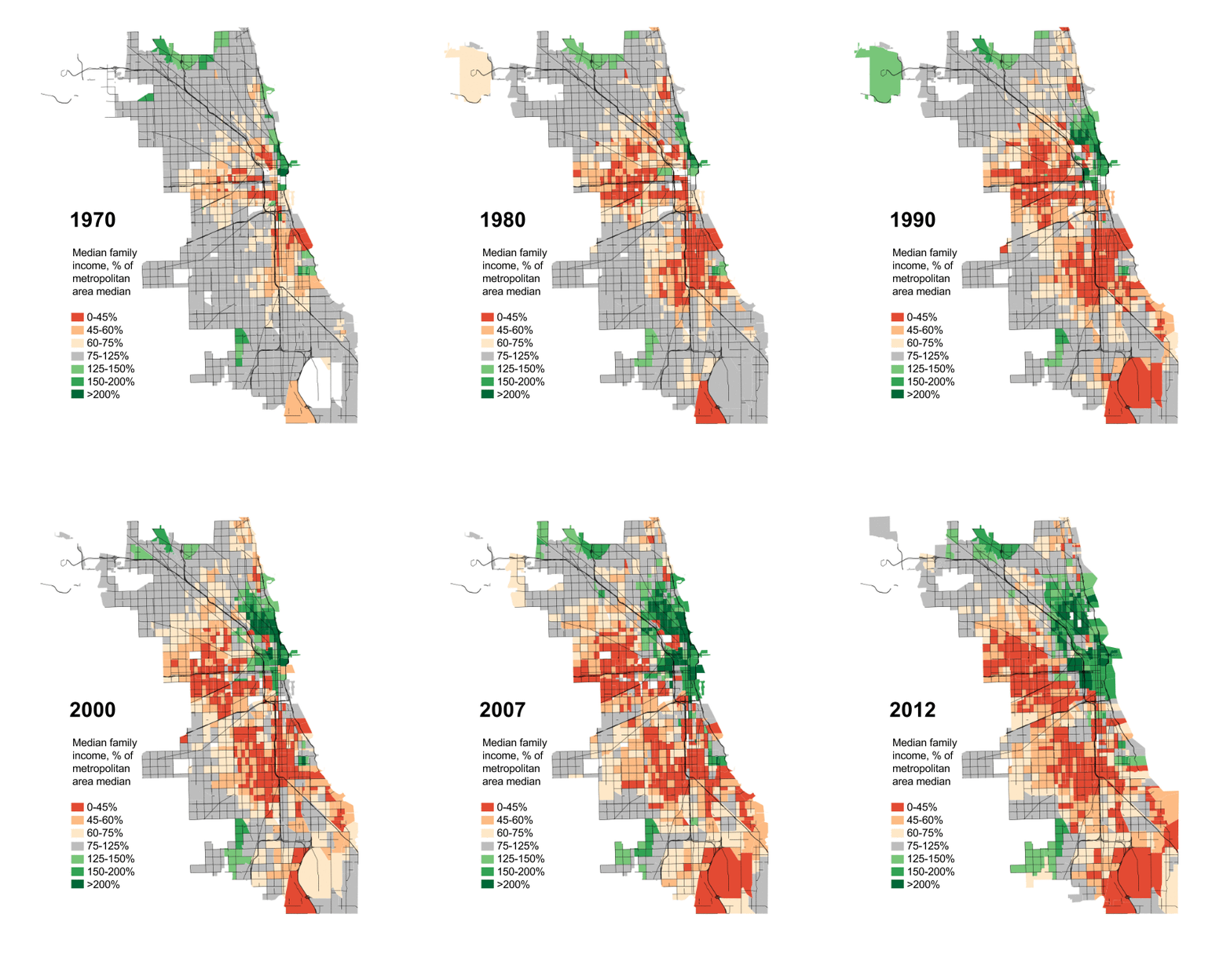
In April of this year we posted an animated map showing Chicago's vanishing middle-class. It was from the City Notes website who's author - Daniel Kay Hertz - wrote a recent op-ed to Crain's Chicago Business. That earlier map was interesting as it tracked the income of the many census tracts that make up the City of Chicago.

Now with the map you see above we show a different tact: Where does Chicago's Black middle-class live?

To be sure, the Black middle-class lives throughout the city. They no longer just live in Chatham or Pill Hill although perhaps they were never the exclusive home of the Black middle-class. The maps shown in the Crain's op-ed seems to show the Black-led middle-class households but mainly measures them as a percentage or as numbers. Also they show maps of Asian, Latino, or white middle-class households in Chicago.

Even Mr. Hertz will admit that the maps provided are misleading and it's hard for me to believe that in some of the community areas there are Black middle-class people in those areas that aren't largely Black. The map you see above I would consider much more accurate.

Hertz offer these brief notes:
A FEW NOTES ON THE WHOLE THING

1. The black middle class exists in Chicago. In large numbers. This shouldn't really be news, but speaking in my capacity as a white person who knows a lot of white people and other people of various ethnic backgrounds from the North Side and suburbs and other parts of the country/world, it really is.

2. Perhaps even more important, the vast majority of Chicagoans who are both black and middle-class live on the South Side and, to a lesser extent, the West Side.

3. The concentration of middle-class households varies dramatically from one black neighborhood to another.

4. Still, the majority of Chicagoans who are middle-class and black live in neighborhoods that are mostly not middle-class — as opposed to Chicagoans who are middle-class and white, for whom the opposite is true. In this way, Chicago is pretty similar to the rest of the country.

The takeaway for me is that these maps contradict two of the biggest lies — or, if we're being kind, misconceptions — about the social geography of Chicago. The first is that the black neighborhoods of the South and West sides are an undifferentiated landscape of economic hardship. This is false in a couple of ways. For one, though there are many people who are suffering for want of a decent wage in these areas, there are also many thousands of households that are not (though they are likely still disadvantaged by other consequences of segregation, including poor access to jobs and basic amenities, higher crime, lower-performing schools, etc.).
And here's another good point:
 From a governance perspective, there are lots of reasons you'd want the people in charge of a city to have an accurate impression of the communities they're governing before they start making up policies for them. But also, from a purely social point of view, the fact that most non-black Chicagoans — and the vast majority of non-Chicagoans — can't distinguish between the poorest pockets of the city and places like Calumet Heights or Park Manor means that they won't ever visit, spend money and certainly won't consider living in neighborhoods that they likely would find generally pleasant. In short, it's hard to build much of a local economy in a place that 75 percent of the population shuns without even thinking about it.
Something to think about. Even then, what could residents of these "shunned" communities do to attract people to their neighborhoods even to just visit?

You should read the whole thing when you get an opportunity.

Thursday, July 10, 2014

Capitol Fax: A sign of the times

Lakeside
Earlier today Rich Miller of the Capitol Fax opined on the coming Mariano's store at the former US Steel South Works and current Chicago Lakeside site. I was not certain what his point were but it sure sparked a number of comments in the post. All the same perhaps his "not feeling like jumping up and down with joy" is related to this point:
At its peak, US Steel employed 20,000 people at its South Works plant. Those were very hard, dangerous, “he-man” jobs, but steelworkers gave an honest day’s work for an honest day’s pay.
Redeveloping this massive site that billed as larger than Chicago's Loop certainly requires a long-term plan. Still I wonder how many people lament the loss of those jobs when US Steel shut down operations here more than 20 years ago?

The image to the left is of the Lakeside development click the pic for a larger resolution.

Monday, June 9, 2014

WBEZ: Watch Chicago's 2nd Ward fly north over the years

The remap that was approved in 2012 has returned to the news recently. WBEZ reports on the history of the 2nd Ward and how and where it was drawn over the years. It was discussed in light of a case before federal court regarding the 2012 remap. It was noted that since 1980, three out of four remaps were challenged.

Back during the whole remap debate, this issue proved to be controversial amongst the many residents of the 6th Ward. Many of the neighborhoods contained within didn't want to be mapped out of the 6th although this came to pass anyway. Many cited similarities to the other communities of the 6th Ward such as Chatham (which remains in the 6th) and West Chesterfield (which ultimately was remapped into the 9th Ward).

All the same, I'm pretty sure Mayor Rahm Emanuel and his allies wouldn't have put forward a map if they didn't think it would prevail in a courtroom. As for that idea whenever there is a ruling - how do i find out about the ruling is the next question - we shall see if the remap expected to be implemented by the 2015 elections will prevail or not.
  • Check out the redistricting label for previous posts on the ward remap!

Saturday, April 19, 2014

City Journal: Chicago's Vanishing Middle Class


Click for larger resolution
This article by Aaron Renn who writes The Urbanophile blog further discusses Chicago's vanishing middle class. Earlier this month I showed an animated image that illustrated middle class areas go from either very wealthy to very poor since 1970s. That image you will see to the right.

If you believe that Mayor Rahm Emanuel may not be entirely responsive to the plight of middle class people in the city perhaps there are some political aspects involved:
The plight of the middle class in cities like Chicago can’t be blamed entirely on liberal policies. The global economy has clearly benefited the talented, the educated, and the already wealthy, often at the expense of those in formerly middle-class occupations, like manufacturing. And it’s unlikely that the forces unleashed by globalization will diminish. One might expect, then, that big-city Democratic leaders like Emanuel or de Blasio would make a strong appeal to middle-class constituents.

They haven’t, because for liberal mayors, middle-class decline is convenient and politically advantageous. Much of America’s moneyed elite has already shifted its allegiance to the Left, especially in cities. Wealthy, educated urbanites hold generally liberal social values and can afford the higher taxes “blue” cities like Chicago impose—especially when those taxes help pay for the upscale amenities they desire. Even when the mayoral administration is less friendly, the urban elite tends to get its needs met. At the same time, the urban poor have remained loyal to the Democrats, no matter how little tangible improvement liberal policies make in their lives. And the various unions, community organizers, and activist groups that advocate for the poor profit handsomely from the moneys directed toward liberal antipoverty programs.

This is the Democratic Party’s new top-bottom coalition, one in which the traditional middle class—white ethnics, blue-collar manufacturing and trade workers, small business owners, and others—has no part. These “left-outs” are the urban equivalents of Reagan Democrats. Their instinct to vote Democratic may remain, but the economic interests that once bound them to the party have largely disappeared, leaving them politically unaffiliated. They are open to voting for a compelling Republican, such as Rudolph Giuliani—particularly if the city in which they live appears to be spiraling downward.

In other words, these independent-minded, urban middle classes are quintessential swing voters. They can create political trouble for an unsympathetic mayor—and that’s why leaders in Chicago, New York, and elsewhere aren’t going to lift a finger to try to halt their flight. Indeed, in Chicago, even the black middle class is bailing. The city’s leadership appears unconcerned.
Read the whole thing!

Sunday, April 6, 2014

City Notes: Watch Chicago’s middle class vanish before your very eyes

Click pic for larger resolution
I'm sorry I missed this as this was shared on Friday via The Capitol Fax. The animated image you see above is a documentation of Chicago's shrinking middle-class since 1970. The middle-class areas are those you will see in grey. Bascially this map measures "each Census tract’s median family income as a percentage of the median family income for the Chicago metropolitan region as a whole".

It's interesting to read the comments on both sites although unfourtately CapFax has since closed their comments for the weekend. That doesn't mean we can't continue to discuss the many changes and the factors that cause the middle-class to leave the city.

BTW, last year I posted one factor why middle-class families move to the suburbs and then recently found another article which chronicled another city family who is leaving the city. These families blame CPS schools for their decision. Perhaps it's one reason amongst others and the City Notes post seeks to further explain the shrinkage.

Either way I'm sure there are plenty of ideas to discuss this issue.

Wednesday, February 5, 2014

Who's buying Chicago-area Dominick's stores?

2101 E. 71st St. by DNA Info's Quinn Ford
Crain's recently shared a Google Maps graphic of all the Chicago area Dominick's stores and what their current status is. It was in the news recently that Whole Foods Market will take over some of Dominick's former locations. This is of interest because at the moment the one that closed in South Shore located at 2101 E. 71st St. - blogged here in December - remains vacant waiting for a new store to set up shop. Anyone in South Shore have an idea who they would like to see take over that spot?